Book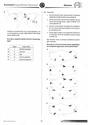
Q 10 · lqa_6beff455_deneme-04_10
DENEME-04 · Coğrafya
needs-reviewgrouped → lqg_6beff455_deneme-04_10_10
Rendered preview
Plain-text approximation. Final renderer is separate.
Stem
Buna göre I, II, III ve IV numaralı kentler aşağıdakilerden hangisinde tümü doğru olarak gösterilmiştir?
[figure fig_lqa_6beff455_deneme-04_10_1]
Options
A
Harita A (I: Trabzon, II: Adana, III: Antalya, IV: Erzurum)
misconception: Kentlerin coğrafi konumları ile ekonomik özellikleri yanlış eşleştirilmiştir.
B
correctHarita B (I: İzmir, II: Samsun, III: Antalya, IV: Erzurum)
C
Harita C (I: Mersin, II: Samsun, III: Muğla, IV: Kars)
misconception: Liman ve tarım kenti eşleştirmelerinde hata yapılmaktadır.
D
Harita D (I: İstanbul, II: Bursa, III: Antalya, IV: Erzurum)
misconception: Sanayi ve turizm odaklı kentlerin haritadaki yerleri karıştırılmaktadır.
E
Harita E (I: Samsun, II: Adana, III: Antalya, IV: Erzurum)
misconception: Transit ticaret limanı olan kentin Karadeniz'deki konumu yanlış belirlenmiştir.
Validation errors
1 issue
figure-needs-redraw
extractor saw a figure: "Beş farklı Türkiye haritası üzerinde I, II, III ve IV numaralı noktalar farklı şehirleri (İzmir, Samsun, Antalya, Erzurum vb.) temsil edecek şekilde işaretlenmiştir.". Reviewer must redraw as TikZ/SVG before promotion.
Source pages
LQF JSON
Raw extraction output
{
  "id": "lqa_6beff455_deneme-04_10",
  "kind": "grouped",
  "stem": [
    {
      "id": "lqa_6beff455_deneme-04_10-stem-17",
      "runs": [
        {
          "node": "text",
          "text": "Buna göre I, II, III ve IV numaralı kentler aşağıdakilerden hangisinde tümü doğru olarak gösterilmiştir?"
        }
      ],
      "type": "text"
    },
    {
      "id": "lqa_6beff455_deneme-04_10-fig-18",
      "type": "figure",
      "figure": {
        "version": 1,
        "figureRef": "fig_lqa_6beff455_deneme-04_10_1"
      },
      "caption": [
        {
          "id": "lqa_6beff455_deneme-04_10-fig-cap-19",
          "runs": [
            {
              "node": "text",
              "text": "Beş farklı Türkiye haritası üzerinde I, II, III ve IV numaralı noktalar farklı şehirleri (İzmir, Samsun, Antalya, Erzurum vb.) temsil edecek şekilde işaretlenmiştir."
            }
          ],
          "type": "text"
        }
      ]
    }
  ],
  "answer": {
    "optionId": "opt-b"
  },
  "status": "needs-review",
  "options": [
    {
      "id": "opt-a",
      "label": "A",
      "content": [
        {
          "id": "lqa_6beff455_deneme-04_10-a-12",
          "runs": [
            {
              "node": "text",
              "text": "Harita A (I: Trabzon, II: Adana, III: Antalya, IV: Erzurum)"
            }
          ],
          "type": "text"
        }
      ],
      "correct": false,
      "misconception": "Kentlerin coğrafi konumları ile ekonomik özellikleri yanlış eşleştirilmiştir."
    },
    {
      "id": "opt-b",
      "label": "B",
      "content": [
        {
          "id": "lqa_6beff455_deneme-04_10-b-13",
          "runs": [
            {
              "node": "text",
              "text": "Harita B (I: İzmir, II: Samsun, III: Antalya, IV: Erzurum)"
            }
          ],
          "type": "text"
        }
      ],
      "correct": true
    },
    {
      "id": "opt-c",
      "label": "C",
      "content": [
        {
          "id": "lqa_6beff455_deneme-04_10-c-14",
          "runs": [
            {
              "node": "text",
              "text": "Harita C (I: Mersin, II: Samsun, III: Muğla, IV: Kars)"
            }
          ],
          "type": "text"
        }
      ],
      "correct": false,
      "misconception": "Liman ve tarım kenti eşleştirmelerinde hata yapılmaktadır."
    },
    {
      "id": "opt-d",
      "label": "D",
      "content": [
        {
          "id": "lqa_6beff455_deneme-04_10-d-15",
          "runs": [
            {
              "node": "text",
              "text": "Harita D (I: İstanbul, II: Bursa, III: Antalya, IV: Erzurum)"
            }
          ],
          "type": "text"
        }
      ],
      "correct": false,
      "misconception": "Sanayi ve turizm odaklı kentlerin haritadaki yerleri karıştırılmaktadır."
    },
    {
      "id": "opt-e",
      "label": "E",
      "content": [
        {
          "id": "lqa_6beff455_deneme-04_10-e-16",
          "runs": [
            {
              "node": "text",
              "text": "Harita E (I: Samsun, II: Adana, III: Antalya, IV: Erzurum)"
            }
          ],
          "type": "text"
        }
      ],
      "correct": false,
      "misconception": "Transit ticaret limanı olan kentin Karadeniz'deki konumu yanlış belirlenmiştir."
    }
  ],
  "premise": {
    "ref": "lqg_6beff455_deneme-04_10_10"
  },
  "section": "DENEME-04",
  "subject": "Coğrafya",
  "groupRef": "lqg_6beff455_deneme-04_10_10",
  "pageNumbers": [
    36
  ],
  "spansToNext": false,
  "formatVersion": "0.1.0",
  "questionNumber": 10,
  "validationErrors": [
    {
      "code": "figure-needs-redraw",
      "message": "extractor saw a figure: \"Beş farklı Türkiye haritası üzerinde I, II, III ve IV numaralı noktalar farklı şehirleri (İzmir, Samsun, Antalya, Erzurum vb.) temsil edecek şekilde işaretlenmiştir.\". Reviewer must redraw as TikZ/SVG before promotion."
    }
  ],
  "continuesFromPrevious": false
}